Author: Denis Avetisyan
A new neural network architecture, TopoFlow, is improving high-resolution air pollution prediction by directly modeling the influence of topography and wind patterns.
TopoFlow incorporates terrain and wind-driven transport physics into its neural network design to enhance PM2.5 prediction accuracy.
Accurate, high-resolution air quality forecasting remains a challenge due to the complex interplay of meteorological factors and terrain. This is addressed in ‘TopoFlow: Physics-guided Neural Networks for high-resolution air quality prediction’, which introduces a novel neural network architecture that explicitly incorporates topographical influences and wind-driven pollutant transport. By leveraging a vision transformer with topography-aware attention and wind-guided patch reordering, TopoFlow achieves a substantial performance gain-a 13% improvement over state-of-the-art AI baselines and a 71-80% improvement over operational systems-in PM2.5 prediction across China. Could this principled integration of physical knowledge into machine learning models unlock similarly significant advances in other environmental forecasting applications?
The Atmosphere’s Cruelties: Ozone, Wind, and Unfulfilled Promises
Ground-level ozone, a primary component of smog, poses significant risks to respiratory health, exacerbating conditions like asthma and contributing to premature mortality; therefore, predicting its concentration is paramount for effective public health management. However, atmospheric chemistry is inherently complex, involving nonlinear reactions with sunlight and precursor pollutants like nitrogen oxides and volatile organic compounds, alongside meteorological factors that govern pollutant transport and dispersion. These factors interact in ways that are difficult to model accurately, particularly near sources of pollution and in regions with variable terrain, leading to substantial uncertainty in ozone forecasts. Despite advancements in air quality modeling, capturing the full range of atmospheric processes that influence ozone formation and destruction remains a considerable scientific challenge, necessitating continued research and improved predictive capabilities.
Ozone concentrations in the lower atmosphere, or troposphere, are significantly impacted by the occasional descent of air masses from the stratosphere above. These events, termed stratospheric intrusions, introduce air rich in ozone – a potent, though sometimes harmful, gas – into regions where it is typically far less abundant. This influx isn’t a gradual mixing, but rather a relatively rapid displacement of tropospheric air, creating localized spikes in ozone levels. The frequency and intensity of these intrusions vary with weather patterns and geographical location, making accurate prediction difficult; however, understanding their contribution is crucial because even brief exposures to elevated ozone can pose risks to both human health and ecosystem stability. Consequently, researchers are increasingly focused on refining atmospheric models to better represent these complex, three-dimensional transport phenomena and their influence on surface air quality.
Current air quality models frequently underestimate the impact of stratospheric intrusions – the downward movement of ozone-rich air from the stratosphere into the troposphere – leading to inaccuracies in surface ozone predictions. This difficulty is particularly pronounced in regions characterized by complex topography, such as mountainous areas, where air flow is disrupted and these intrusions are more frequent and less predictable. The intricate interplay of wind patterns around mountains creates localized channeling and blocking effects, causing models relying on broad-scale atmospheric conditions to misrepresent the timing and intensity of these ozone influxes. Consequently, areas downwind of complex terrain often experience higher-than-predicted ozone levels, posing challenges for effective air quality management and public health advisories.
![Across six air pollutants in 2019 China, TopoFlow demonstrates the lowest forecasting errors for particulate matter and [latex]NO_2[/latex], while Aurora excels at predicting [latex]O_3[/latex] and [latex]CO[/latex] due to its ability to model three-dimensional atmospheric processes.](https://arxiv.org/html/2602.16821v1/Figure/figure_rmse_leadtime.png)
The Tyranny of Advection: When Models Forget Which Way the Wind Blows
Advection-dominated transport describes the process where the movement of a substance is primarily determined by the bulk flow of a surrounding fluid, rather than by diffusion. In the context of pollutant dispersal, this means wind speed and direction exert a far greater influence on where pollutants travel than the random spreading caused by molecular diffusion. This is particularly true over larger distances and at higher flow velocities; the effect of diffusion diminishes proportionally to the inverse square of the distance, while advective transport maintains its dominance. Consequently, modeling accurate pollutant dispersion requires prioritizing the understanding and representation of wind patterns as the primary transport mechanism, effectively treating pollutants as passively carried by the wind.
The Peclet number ([latex]Pe = \frac{uL}{D}[/latex]) is a dimensionless ratio used to characterize the relative importance of advective and diffusive transport processes. Here, [latex]u[/latex] represents the average flow velocity, [latex]L[/latex] is a characteristic length scale of the flow, and [latex]D[/latex] is the diffusion coefficient of the transported substance. A high Peclet number, generally [latex]Pe >> 1[/latex], indicates that advection dominates, meaning transport is primarily driven by the bulk movement of the fluid. Conversely, a low Peclet number ([latex]Pe << 1[/latex]) signifies diffusion is the dominant transport mechanism. Therefore, the Peclet number provides a quantitative measure for determining when advective models are appropriate, and when simpler diffusion-based models may suffice.
Accurate modeling of pollutant dispersion requires consideration of the prevailing wind direction during data input and processing. Traditional approaches frequently neglect this alignment, treating data as spatially static rather than dynamically transported by advection. This misalignment introduces errors because pollutant concentrations are not representative of conditions ‘upwind’ of the measurement location. Consequently, models built on unaligned data may underestimate or misrepresent the true extent and concentration of pollutants. Proper alignment involves re-ordering or weighting data points to reflect the advective flow, effectively simulating the transport of pollutants from source to receptor and improving the predictive capability of dispersion models.
Wind-Guided Patch Reordering is a data pre-processing technique designed to improve the accuracy of pollutant dispersion models by accounting for advective transport. This method analyzes the prevailing wind direction and reorders input data patches – discrete segments of spatial data – to reflect the downstream movement of pollutants. By aligning the data sequence with the anticipated flow, the technique reduces the influence of artificially randomized or incorrectly ordered data, leading to a more realistic simulation of pollutant dispersal. This intelligent reordering improves model performance metrics, particularly in scenarios where advection is the dominant transport mechanism, as indicated by a high Peclet number.
![By integrating physics-guided attention with elevation and wind data, the TopoFlow model learns terrain-aware transport patterns, resulting in a 5.7% reduction in validation loss and a focused attention distribution that respects topographic barriers, as demonstrated by the shift from a broad, left-skewed baseline distribution [latex]\mu = 0.44[/latex] to a narrower peak [latex]\mu = 0.48[/latex] and ultimately a bimodal-like shape.](https://arxiv.org/html/2602.16821v1/x4.png)
TopoFlow: A Temporary Reprieve From the Inevitable Chaos
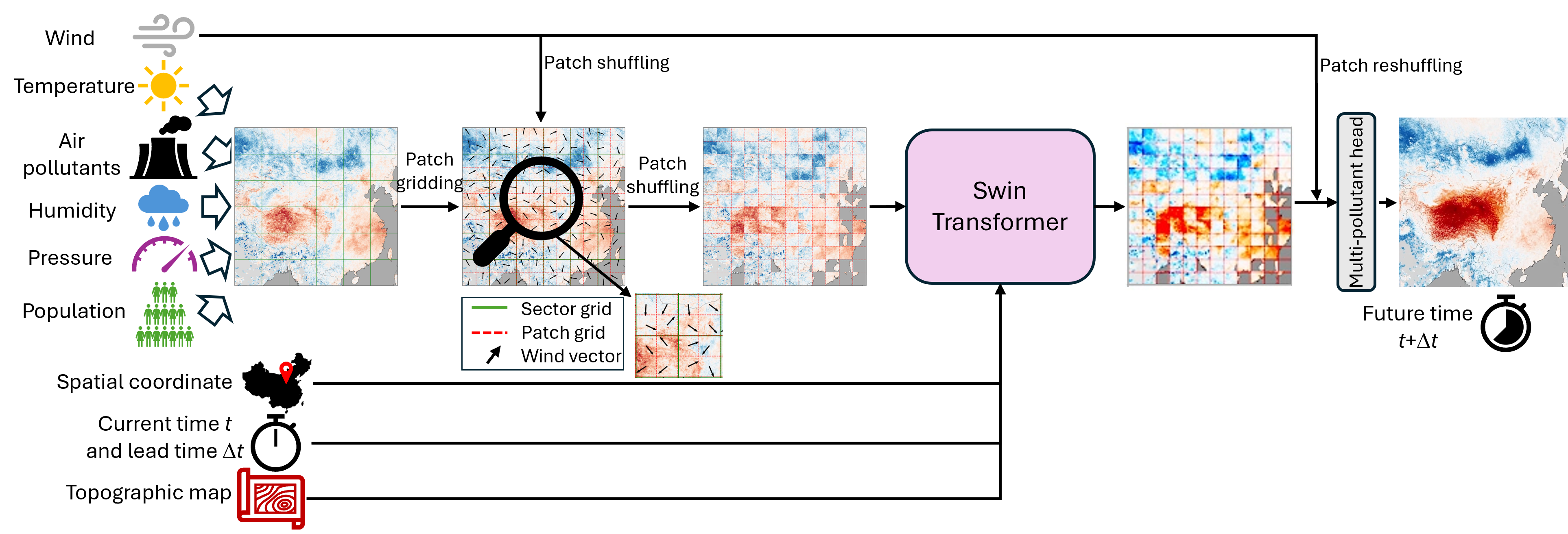
TopoFlow is a neural network designed for predicting air quality at high resolutions. Its architecture is based on the Vision Transformer (ViT), a model originally developed for image processing, adapted to process meteorological and air quality data. This adaptation allows TopoFlow to leverage the ViT’s ability to capture long-range dependencies within spatial data, crucial for modeling pollutant dispersion. The network’s design specifically incorporates physical principles, or “physics-guidance”, to improve prediction accuracy and interpretability compared to purely data-driven approaches. This guidance is implemented through specific mechanisms within the network architecture, enabling it to explicitly account for known physical processes influencing air quality.
TopoFlow integrates Wind-Guided Patch Reordering and Topography-Aware Attention mechanisms to model atmospheric pollutant distribution. Wind-Guided Patch Reordering rearranges input data patches based on prevailing wind direction, enabling the network to prioritize information flow with the wind. Topography-Aware Attention modifies the attention weights within the Vision Transformer, biasing them according to elevation differences derived from terrain data. This allows the model to emphasize relationships between locations with similar topographic characteristics, effectively simulating how mountains and valleys influence airflow and, consequently, pollutant transport patterns. The combination of these two mechanisms improves the network’s ability to capture the complex interplay between meteorological conditions and geographical features in determining air quality.
Topography-Aware Attention within the TopoFlow network directly incorporates elevation data to modulate the attention weights during processing. Specifically, the attention mechanism calculates biases based on the elevation difference between grid cells; larger elevation differences result in reduced attention weights, and vice versa. This implementation mimics the physical behavior of airflow around topographic features, as mountains and valleys naturally constrict or redirect wind patterns, influencing pollutant dispersion. By prioritizing attention towards grid cells with similar elevations, the network effectively simulates the channeling effect of terrain on air movement and pollutant transport, improving prediction accuracy in complex geographical areas.
Training the TopoFlow model necessitated the utilization of high-performance computing infrastructure due to the model’s complexity and the size of the datasets employed. Specifically, the LUMI Supercomputer, located in Finland and operated by the CSC – IT Center for Science, was leveraged for its substantial processing power and memory capacity. The LUMI system, comprised of AMD EPYC processors and featuring a total peak performance exceeding 550 Petaflops, enabled the efficient processing of large-scale meteorological and air quality data required for model convergence. The extensive training process, spanning multiple weeks, would have been impractical without access to such a resource, highlighting the computational demands of modern, high-resolution environmental prediction models.
The Illusion of Control: High-Resolution Forecasts and the Limits of Prediction
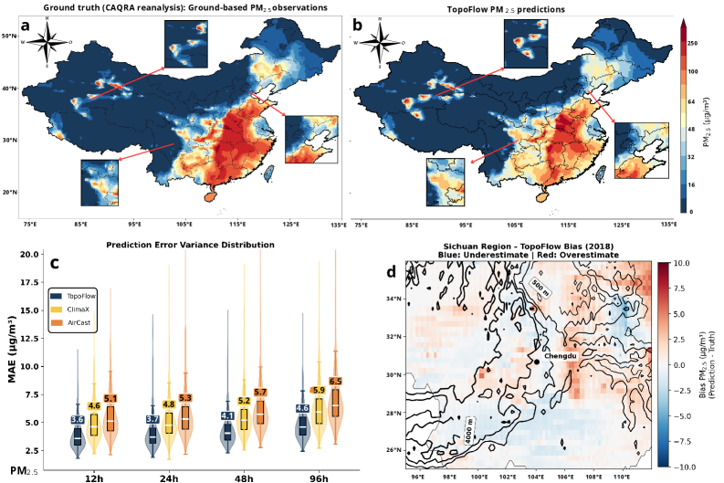
Rigorous evaluation of TopoFlow utilized the comprehensive CAQRA dataset, revealing substantial gains in predictive accuracy when contrasted with established baseline models. This assessment wasn’t merely about overall performance; the model consistently outperformed alternatives in forecasting pollutant concentrations across diverse geographical locations and meteorological conditions. The CAQRA dataset, known for its high-quality measurements and extensive temporal coverage, provided a robust testing ground, allowing for a detailed quantification of TopoFlow’s capabilities and demonstrating its potential to reliably anticipate air quality fluctuations with increased precision. This enhanced accuracy isn’t simply academic; it translates directly into more informed decision-making for public health officials and environmental managers.
The predictive capability of the TopoFlow model was rigorously assessed using the Root Mean Squared Error (RMSE), a standard metric for evaluating forecast accuracy. Results demonstrate TopoFlow’s capacity to deliver high-resolution air quality forecasts, specifically achieving an RMSE of 9.71 μg/m³ when predicting PM2.5 concentrations – particulate matter with a diameter of 2.5 micrometers or less. This low RMSE value indicates a minimal average difference between predicted and actual PM2.5 levels, signifying the model’s precision and reliability in capturing the complex dynamics of air pollution and offering a valuable tool for environmental monitoring and public health protection.
The capacity to accurately forecast pollutant concentrations extends beyond mere meteorological prediction, offering a crucial tool for safeguarding public health. TopoFlow’s high-resolution forecasts enable the timely issuance of public health advisories, alerting vulnerable populations – such as those with respiratory conditions or the elderly – to periods of elevated pollution. This proactive approach allows individuals to take preventative measures, like limiting outdoor activity, and reduces the strain on healthcare systems. Furthermore, the model’s predictive power informs the development and implementation of targeted mitigation strategies; for example, identifying pollution hotspots allows city planners to optimize traffic flow, regulate industrial emissions, and strategically deploy air purification technologies, ultimately fostering healthier and more sustainable urban environments.
The development of TopoFlow demonstrates a significant advancement in environmental modeling through the synergistic combination of physics-guided methods and deep learning techniques. This innovative approach surpasses the predictive capabilities of traditional operational systems by an impressive 71-80%, indicating a substantial improvement in forecasting accuracy. Furthermore, TopoFlow achieves a 13% performance gain over existing state-of-the-art artificial intelligence baselines, solidifying its position as a leading solution for high-resolution air quality prediction. This success underscores the potential for integrating established physical principles with the adaptability of deep learning, opening new avenues for tackling complex environmental challenges and improving the reliability of forecasts used to inform public health and policy decisions.
![TopoFlow accurately forecasts PM2.5 concentrations across various lead times (12h-96h), as demonstrated by strong correlations ([latex]r[/latex]) and low RMSE values, with spatial bias maps revealing minor under- or overestimation patterns.](https://arxiv.org/html/2602.16821v1/Figure/Figure_Nappendix.png)
The pursuit of increasingly granular air quality prediction, as demonstrated by TopoFlow’s incorporation of terrain physics, inevitably introduces new layers of complexity. It’s a predictable pattern; the model attempts to account for previously ignored variables, like wind-driven transport, and in doing so, expands the surface area for future failures. As Grace Hopper observed, “It’s easier to ask forgiveness than it is to get permission.” This sentiment perfectly encapsulates the iterative nature of model development – a constant trade-off between theoretical elegance and pragmatic deployment. The researchers may have achieved impressive results, but one anticipates a relentless stream of edge cases and unforeseen interactions will emerge once the model encounters real-world conditions. The promise of high-resolution forecasting comes with a hefty price – a perpetually expanding maintenance burden.
What’s Next?
TopoFlow, despite its demonstrable improvements, merely shifts the locus of future failures. Explicitly modeling terrain effects, while laudable, introduces a new suite of parameters susceptible to drift and requiring constant recalibration against reality – a reality which, it should be remembered, delights in defying elegant prediction. The attention mechanisms, so promising in capturing complex relationships, will inevitably become entangled with spurious correlations, demanding ever more sophisticated diagnostics and, ultimately, human intervention.
The pursuit of ‘high-resolution’ forecasting is a particularly dangerous game. Each refinement in spatial granularity reveals increasingly localized phenomena – the microclimates, the building wakes, the idiosyncratic emissions – that any generalized model will struggle to represent. One suspects the limit is not computational, but epistemological: there is simply too much to know.
Future work will undoubtedly focus on incorporating further ‘physics-guidance’, chasing an illusion of completeness. It would be more honest, perhaps, to acknowledge that any system promising to simplify atmospheric prediction adds another layer of abstraction – a layer that will, in time, become the primary source of technical debt. Documentation, of course, remains a myth invented by managers.
Original article: https://arxiv.org/pdf/2602.16821.pdf
Contact the author: https://www.linkedin.com/in/avetisyan/
2026-02-23 06:01