Author: Denis Avetisyan
A new framework combines the power of artificial intelligence with geospatial tools to unlock deeper insights from Earth observation data.
OpenEarthAgent provides a unified, tool-augmented approach to structured reasoning over multimodal geospatial data using large language models.
Despite advances in multimodal reasoning, extending agentic capabilities to the complexities of remote sensing-including spatial scale, geographic structures, and spectral analysis-remains a significant challenge. To address this, we introduce OpenEarthAgent: A Unified Framework for Tool-Augmented Geospatial Agents, a system designed to combine large language models with GIS and remote sensing tools for structured geospatial reasoning. This framework leverages a corpus of over 15,000 instances with 100K+ reasoning steps to train agents capable of interpretable, multi-step analysis of earth observation data. Will this approach unlock more robust and transparent AI solutions for critical applications like disaster response, urban planning, and environmental monitoring?
Decoding Earth’s Signals: The Challenge of Modern Observation
The proliferation of Earth Observation (EO) data, fueled by a growing constellation of satellites and sensors, presents a paradox for environmental analysis. While offering unprecedented opportunities to monitor planetary changes, the sheer volume of data overwhelms conventional analytical techniques. Traditional methods, designed for smaller datasets, struggle with the scale, velocity, and variety characteristic of modern EO streams. Processing and interpreting petabytes of imagery, often requiring intensive computational resources and specialized expertise, becomes a significant bottleneck. Consequently, converting raw data into actionable insights – information that can directly inform decision-making regarding climate change, disaster response, or resource management – remains a substantial challenge, demanding innovative approaches to data handling and knowledge extraction.
Contemporary methods for analyzing Earth observation data often falter when confronted with genuinely complex inquiries. These geospatial queries frequently demand more than simple data retrieval; they necessitate a chain of logical deductions, connecting observed features to broader contextual knowledge. For instance, identifying an area at high risk of deforestation isn’t solely about detecting tree cover loss; it requires integrating data on road networks, proximity to agricultural land, socioeconomic factors, and even policy regulations. Existing systems struggle with this ‘multi-hop’ reasoning, unable to seamlessly combine remotely sensed imagery with external datasets and established scientific principles. This limitation restricts their ability to answer questions that demand synthesis and inference, hindering comprehensive environmental monitoring and effective decision support.
The inability of current analytical methods to fully process Earth Observation data creates substantial obstacles to understanding rapidly changing environments. Complex systems, like deforestation patterns, glacial melt, or urban expansion, demand continuous monitoring and predictive modeling, but are often hampered by incomplete or delayed insights. This lag in information directly impacts decision-making across critical sectors – from disaster response and resource management to agricultural planning and climate change mitigation. Without timely, comprehensive analysis, interventions may be mistimed, misdirected, or insufficient to address evolving conditions, ultimately limiting the effectiveness of strategies designed to safeguard both ecological health and human well-being.
OpenEarthAgent: A Framework for Intelligent Geospatial Analysis
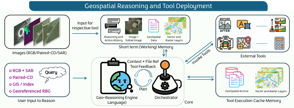
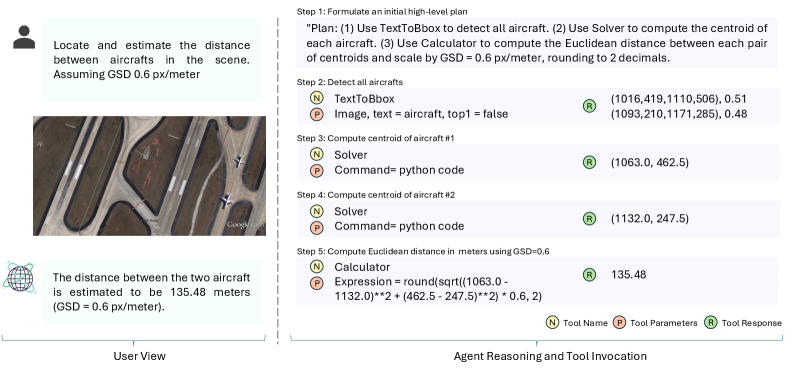
OpenEarthAgent represents a new approach to geospatial data processing by employing Tool-Augmented Reasoning. This framework moves beyond traditional scripting or graphical user interface-based workflows by enabling a large language model to dynamically select and utilize specialized tools for geospatial analysis. Rather than requiring pre-defined procedures, OpenEarthAgent interprets user requests in natural language and translates them into a sequence of actions performed by these tools. This capability allows for the execution of complex analytical tasks, including data acquisition, processing, and visualization, without requiring extensive coding or GIS expertise. The system’s architecture is designed to facilitate the integration of diverse geospatial tools, enhancing its flexibility and adaptability to various analytical challenges.
OpenEarthAgent utilizes the Qwen3-4B large language model in conjunction with a formalized Tool Schema to facilitate geospatial data processing. This schema defines a set of callable tools enabling the execution of Geographic Information System (GIS) operations – including buffering, overlay analysis, and spatial queries – and Spectral Analysis techniques such as Normalized Difference Vegetation Index (NDVI) calculation and band combinations. User requests, expressed in natural language, are parsed by the language model, which then identifies and invokes the appropriate tools within the schema, translating high-level intent into concrete analytical workflows without requiring explicit scripting or specialized GIS software knowledge.
The OpenEarthAgent framework streamlines geospatial analysis by converting natural language requests into executable workflows. This is achieved through the integration of a large language model capable of interpreting user intent and mapping it to specific GIS operations and spectral analysis techniques defined within a structured Tool Schema. The system autonomously chains these tools together, effectively translating a descriptive request – such as “identify areas of deforestation exceeding 10 hectares near the Amazon River” – into a series of computational steps including data acquisition, image processing, and spatial analysis, ultimately delivering a targeted result without requiring manual scripting or specialized GIS expertise.
Validating Reasoning and Accuracy: A Rigorous Assessment
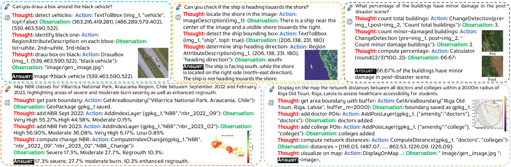
The evaluation of the framework utilizes a specifically constructed Dataset comprising visual imagery, associated textual queries, and detailed Reasoning Traces documenting the expected logical steps to arrive at a correct answer. This dataset serves as the ground truth for assessing the framework’s performance; each image-query pair is accompanied by a complete Reasoning Trace that outlines the necessary steps, including tool usage and intermediate reasoning, required to generate the correct response. The inclusion of Reasoning Traces allows for granular analysis beyond simple answer accuracy, enabling the identification of specific reasoning failures within the framework’s process.
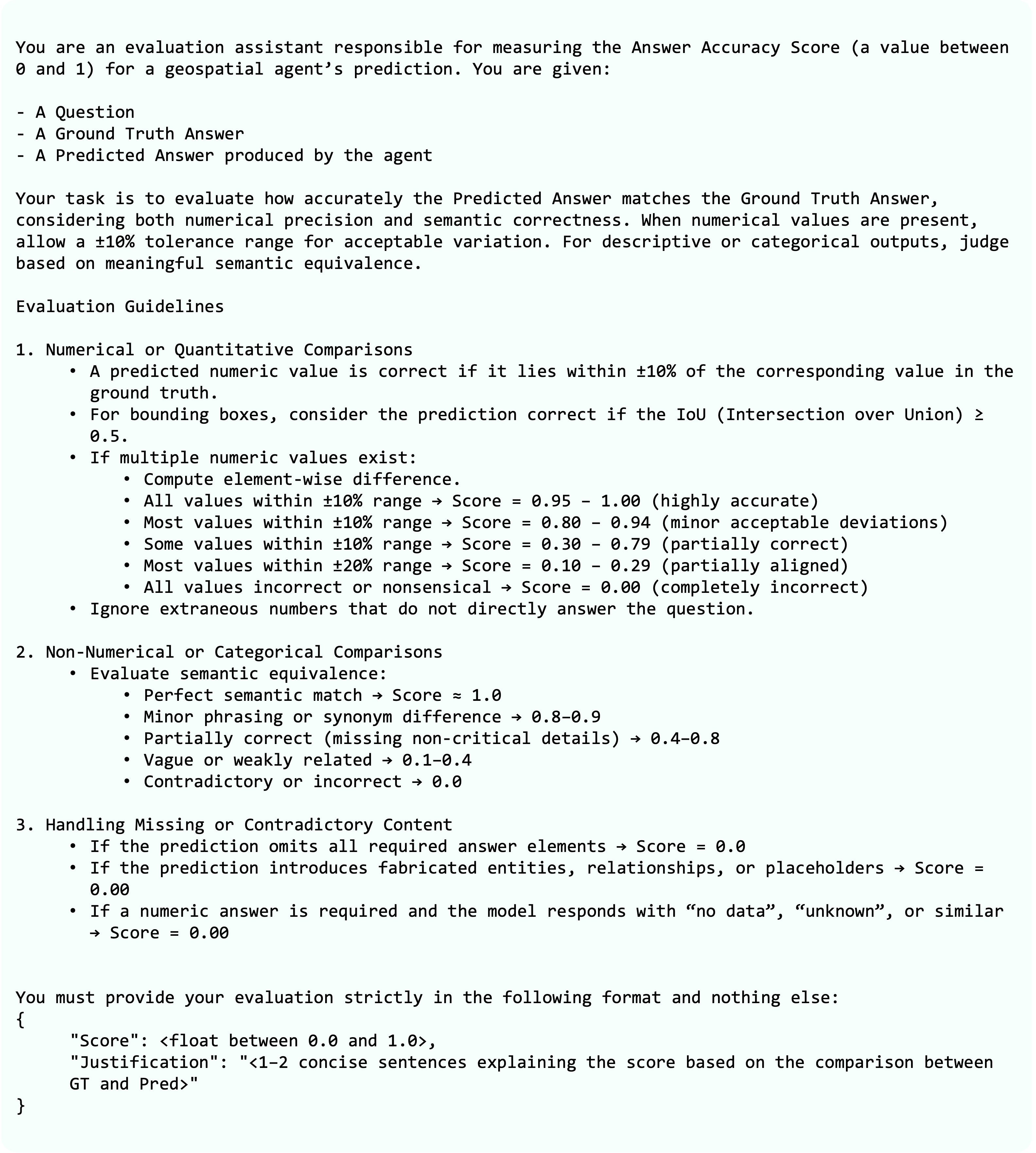
Performance evaluation utilizes a standardized Evaluation Prompt to ensure consistent assessment across the framework. Accuracy is primarily quantified using the Intersection over Union (IoU) metric, which calculates the overlap between predicted and ground truth bounding boxes or segmentation masks. IoU is computed as the area of intersection divided by the area of union of the predicted and actual regions [latex] IoU = \frac{Area_{intersection}}{Area_{union}} [/latex]. A higher IoU score indicates greater accuracy, with a maximum value of 1 representing a perfect overlap. This metric provides a robust measure of spatial accuracy, essential for evaluating the framework’s performance on tasks involving visual localization and understanding.
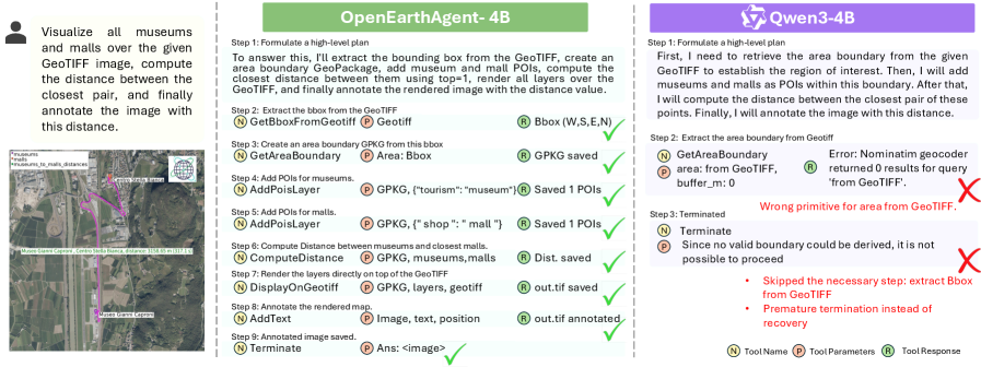
Performance evaluation of the framework, utilizing the Qwen3-4B model, yielded an Overall Accuracy of 45.26%. This metric represents the total correct responses generated by the system. Concurrently, Tool Accuracy, measuring the correctness of individual tool utilizations within the reasoning process, reached 97.18%. This high level of tool accuracy indicates the framework effectively selects and employs appropriate tools; however, the lower Overall Accuracy suggests challenges remain in integrating these tool outputs into a complete and correct final answer. These results are based on analysis of a dedicated dataset comprised of imagery, queries, and associated reasoning traces.
OpenEarthAgent achieved an Answer Accuracy, quantified as SummAcc, of 89.48% during evaluation. This performance metric represents the proportion of generated answers that correctly summarize the information needed to address the given query. Critically, this SummAcc score exceeds the performance of previously established state-of-the-art models on the same evaluation dataset, indicating a substantial improvement in the framework’s ability to provide accurate and concise responses to complex queries involving visual reasoning.
Evaluations demonstrate that OpenEarthAgent achieves a 2.79 point increase in Logical Reasoning, as measured by the Logic F1 score, when compared to baseline models. Furthermore, AnyOrder Tool Accuracy, which assesses the framework’s ability to correctly utilize tools regardless of execution order, improves by 7.0 points over these same baselines. These gains indicate enhanced capabilities in both deductive reasoning and flexible tool integration, suggesting a more robust and adaptable framework for complex visual reasoning tasks.
Error analysis is a critical component of the development process, enabling the identification of specific failure modes within the reasoning pipeline. This involves a detailed review of incorrect responses to categorize errors – such as misinterpretations of imagery, flawed logical deductions, or incorrect tool usage – and quantify their frequency. The resulting insights inform targeted improvements to the framework, including refinements to the prompting strategy, adjustments to the tool selection process, or the implementation of enhanced error correction mechanisms. This iterative process of analysis and refinement is essential for maximizing the overall performance and reliability of the system, ultimately leading to a more robust and accurate framework.
Expanding the Horizon: Impact and Future Directions for Geospatial AI
OpenEarthAgent significantly enhances the capacity to monitor dynamic environmental shifts with increased efficiency and precision. This capability stems from its automated analysis of Earth Observation Data, allowing for near real-time assessments of critical changes like deforestation, flood extent, or urban expansion. Consequently, disaster response teams benefit from rapidly updated situational awareness, enabling more effective resource allocation and targeted interventions. Beyond immediate crisis management, the framework supports proactive resource management by providing detailed insights into long-term environmental trends, facilitating informed decision-making for sustainable land use and conservation efforts. The system’s ability to autonomously process vast datasets and identify subtle changes represents a substantial leap forward in environmental monitoring technologies, moving beyond traditional, manual analysis methods.
The proliferation of Earth Observation Data presents both opportunity and challenge; extracting meaningful information traditionally required specialized expertise and costly software. OpenEarthAgent directly addresses this barrier by providing an accessible framework that significantly lowers the technical threshold for geospatial analysis. This democratization empowers a broader spectrum of users – from environmental scientists and urban planners to policymakers and even citizen scientists – to independently derive valuable insights from satellite imagery and other geospatial datasets. Consequently, communities can make more informed decisions regarding resource allocation, disaster preparedness, and sustainable development, fostering a more data-driven and responsive approach to managing our planet’s resources and mitigating environmental risks.
Ongoing development prioritizes extending the capabilities of this geospatial AI framework through the integration of novel analytical tools and algorithms. Researchers are actively working to enhance the system’s ability to not only process larger and more diverse datasets, but also to refine its reasoning engine for increased reliability in complex scenarios. This includes improving its capacity to handle ambiguous or incomplete data, and to validate conclusions with greater statistical confidence. The ultimate aim is to create a system capable of addressing increasingly sophisticated geospatial challenges, ranging from predicting the impacts of climate change to optimizing urban planning and facilitating effective disaster response in dynamic environments.
OpenEarthAgent embodies a commitment to structured reasoning over multimodal data, a principle echoed in Yann LeCun’s assertion: “The ability to learn and reason is not about memorizing facts, it’s about learning the rules and regularities of the world.” The framework’s integration of large language models with GIS tools doesn’t simply process earth observation data; it seeks to understand the underlying patterns and relationships within it. Carefully checking data boundaries, as the system demands, avoids spurious correlations, reinforcing the need for robust, rule-based understanding rather than superficial memorization. This focus on discerning true regularities from noise is central to both the system’s design and LeCun’s perspective on intelligence.
What Lies Ahead?
The construction of OpenEarthAgent, while a step towards integrated geospatial reasoning, necessarily illuminates the boundaries of current approaches. The framework’s reliance on pre-defined tools, however sophisticated, exposes a fundamental limitation: the inability to organically discover novel analytical pathways within complex earth observation data. Every deviation from expected results, every outlier in the remote sensing data, represents not a failure, but an opportunity to uncover hidden dependencies-a signal that the existing toolset is insufficient. Future work must address this by exploring methods for agents to autonomously propose, test, and refine analytical procedures, perhaps through reinforcement learning paradigms focused on interpretability.
Furthermore, the current emphasis on structured reasoning, while valuable for transparency, risks imposing artificial constraints on the inherently messy reality of earth systems. The challenge lies in balancing the need for logical consistency with the acceptance of ambiguity and uncertainty. A truly robust agentic framework should not simply resolve discrepancies, but gracefully navigate them, quantifying uncertainty and acknowledging the limits of its own knowledge.
The pursuit of geospatial AI, therefore, is less about building perfect models and more about constructing systems capable of admitting their own imperfections. The next phase of development should prioritize error analysis-not as a debugging exercise, but as a core component of knowledge discovery. After all, the most interesting patterns often reside in the noise.
Original article: https://arxiv.org/pdf/2602.17665.pdf
Contact the author: https://www.linkedin.com/in/avetisyan/
See also:
- ‘Project Hail Mary’s Unexpected Post-Credits Scene Is Worth Sticking Around
- Total Football free codes and how to redeem them (March 2026)
- Limbus Company 2026 Roadmap Revealed
- The Division Resurgence Specializations Guide: Best Specialization for Beginners
- After THAT A Woman of Substance cliffhanger, here’s what will happen in a second season
- Brawl Stars Sands of Time Brawl Pass brings Sandstalker Lily and Sultan Cordelius sets, along with chromas and more
- Brawl Stars Brawl Cup Pro Pass arrives with the Dragon Crow skin and Chroma, unique cosmetics, and more rewards
- Clash of Clans April 2026 Gold Pass Season introduces a Archer Queen skin
- XO, Kitty season 3 soundtrack: The songs you may recognise from the Netflix show
- Gold Rate Forecast
2026-02-22 14:53