Author: Denis Avetisyan
Researchers have developed a new AI agent capable of sophisticated geospatial reasoning by integrating established geographic science principles with cutting-edge artificial intelligence.
Spatial-Agent leverages GeoFlow Graphs and knowledge graphs to achieve more accurate and interpretable reasoning over spatial data compared to existing large language model-based agents.
While large language models show promise in various domains, genuine geospatial computation remains a challenge, often relying on superficial pattern matching rather than rigorous analysis. This paper introduces ‘Spatial-Agent: Agentic Geo-spatial Reasoning with Scientific Core Concepts’, an AI agent grounded in spatial information science that addresses this limitation. By formalizing geo-analytical question answering as a concept transformation problem and representing workflows as interpretable GeoFlow Graphs, Spatial-Agent significantly outperforms existing LLM-based agents on complex geospatial tasks. Could this approach unlock more reliable and explainable AI solutions for critical applications like urban planning and disaster response?
The Illusion of Spatial Intelligence
Current geospatial question answering systems frequently falter when presented with inquiries demanding more than simple data retrieval. These systems typically excel at responding to straightforward requests – “What is the population of London?” – but struggle with complex questions necessitating multiple analytical steps and the integration of diverse datasets. For example, a query like “Identify areas suitable for solar farms, considering slope, proximity to transmission lines, and land use restrictions” requires the system to not only access relevant data layers, but also to perform spatial analysis, apply constraints, and synthesize results – a process that often exceeds the capabilities of traditional approaches. This limitation stems from a reliance on keyword matching and semantic parsing, rather than a deep understanding of spatial relationships and analytical workflows, hindering the effective translation of human intent into actionable geographic intelligence.
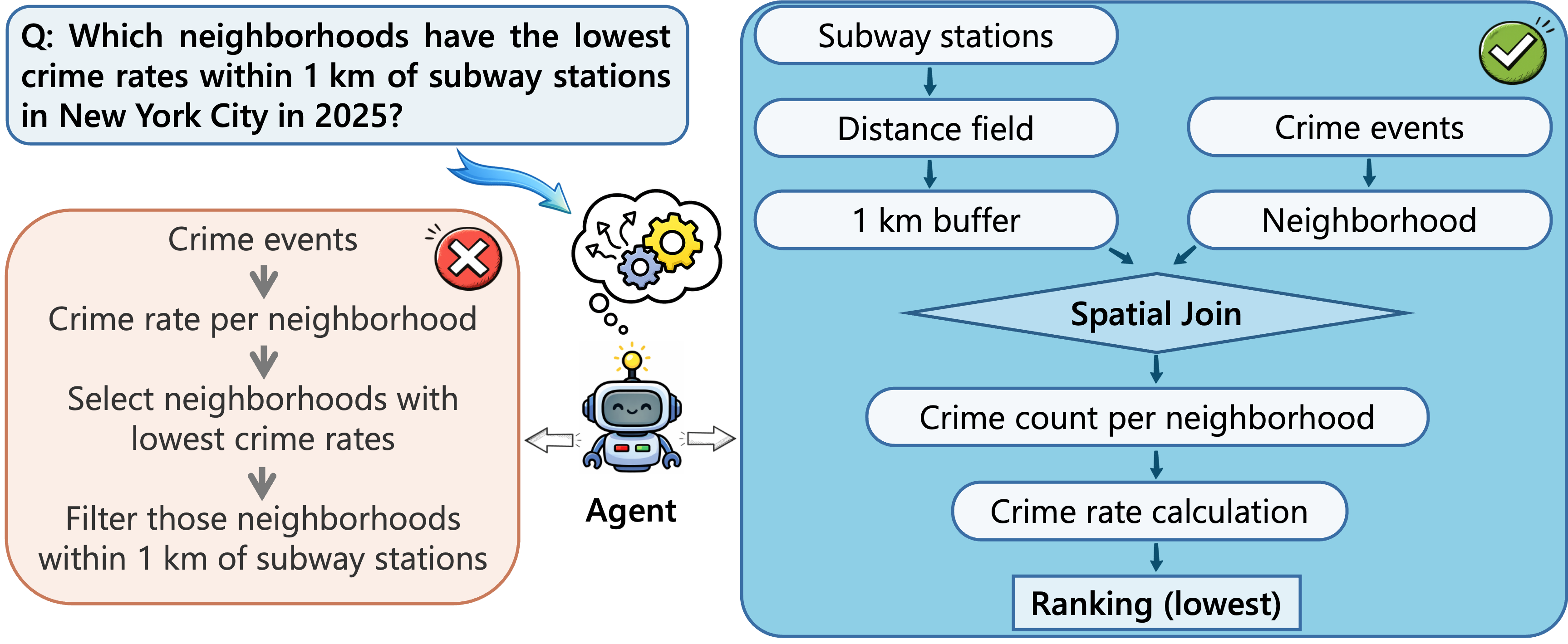
Current approaches to geospatial question answering frequently fall into the trap of processing spatial data as mere text strings, a practice that fundamentally disregards the intrinsic relationships and structures defining geographic phenomena. This textual treatment obscures vital information – the adjacency of regions, the containment of features within boundaries, or the topological connections between networks – which are crucial for accurate analysis. Consequently, systems struggle to ‘understand’ spatial queries that require reasoning about these relationships, leading to inaccurate or incomplete responses. Treating location not as a coordinate or label, but as a core component of the data’s organization, is essential for building truly intelligent geospatial systems capable of complex reasoning and insightful discoveries.
The effective translation of human geospatial queries into actionable steps remains a significant challenge in modern geographic information systems. Current limitations necessitate the development of systems capable of dissecting complex questions-such as identifying areas susceptible to flooding given projected sea-level rise and rainfall patterns-into a series of discrete, executable workflows. These workflows would involve automated data retrieval, spatial analysis techniques, and iterative refinement based on intermediate results. Bridging this gap between human intent and machine action requires not simply understanding the words of a query, but also inferring the underlying analytical process and translating it into a computational framework. Such systems promise to move beyond simple data retrieval towards true geospatial reasoning, enabling more sophisticated and automated solutions to complex environmental and societal problems.
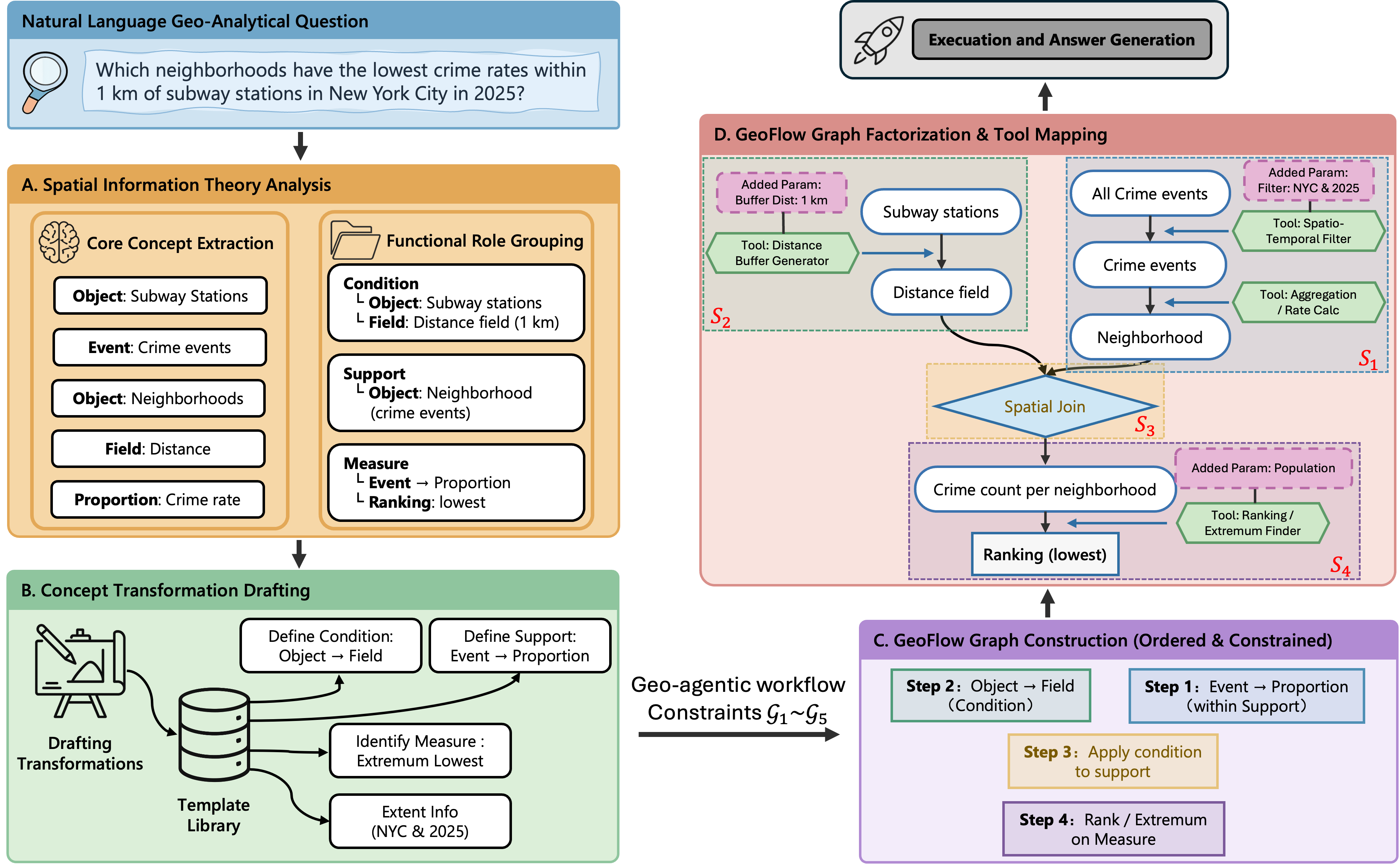
The GeoFlow Graph: Mapping Intent to Execution
The GeoFlow Graph is designed as an intermediary data structure to translate natural language geospatial queries into a format suitable for automated processing. It achieves this by representing the query’s meaning – its underlying semantics – as a directed graph where nodes represent operations and edges define the flow of data between them. This graph-based representation isn’t merely a symbolic parsing of the question; it’s an executable workflow, meaning the graph can be directly interpreted and executed by a spatial processing engine to produce a result. The GeoFlow Graph therefore serves as a bridge between human-understandable questions and machine-actionable instructions, enabling systems to ‘understand’ and respond to complex geospatial requests.
The GeoFlow Graph’s structural integrity relies on the integration of established ‘GIScience Core Concepts’ – including geometric primitives, topological relationships, and spatial scales – alongside defined ‘Functional Roles’ which categorize operations based on their purpose, such as aggregation, filtering, or transformation. This foundation ensures the graph accurately represents the semantic meaning of a geospatial query by mapping inputs and operations to recognized spatial principles and functionalities. Specifically, nodes within the graph represent spatial objects or data, while edges define relationships and functional roles, enabling a formal and unambiguous representation necessary for automated spatial reasoning and query execution.
Decomposition of complex geospatial queries into a series of well-defined operations is achieved through the GeoFlow Graph by representing each operation as a node and data dependencies as edges. This modularity allows for parallel execution of independent operations, improving processing efficiency. Furthermore, the explicit representation of each step in the workflow facilitates interpretation and debugging; each node’s function is clearly defined, enabling systematic tracing of data transformations and identification of potential errors. This structured approach contrasts with monolithic query processing, where the entire query is treated as a single unit, hindering both optimization and understanding of the analytical process.
Spatial-Agent: Formalizing the Question
The Spatial-Agent reframes geo-analytical question answering not as a direct information retrieval task, but as a process of transforming a user’s natural language query into a formal, executable workflow. This is achieved by identifying key spatial concepts – such as locations, geometries, and relationships – within the question and mapping them to corresponding operations within a GeoFlow graph. By formalizing the problem as concept transformation, the agent can decompose complex queries into a series of well-defined steps, enabling automated execution and analysis of spatial data. This approach allows the agent to move beyond simple keyword matching and achieve a deeper understanding of the user’s intent, facilitating more accurate and reliable results.
Supervised fine-tuning is employed to improve the Spatial-Agent’s ability to interpret user queries by specifically identifying spatial concepts and their associated functional roles. This process involves training the agent on a dataset of question-concept-role triplets, enabling it to accurately parse natural language and extract key elements required for geo-analytical workflows. The fine-tuning focuses on discerning spatial entities – such as locations, regions, or geometric shapes – and assigning the appropriate functional role to each, like ‘target’, ‘source’, ‘constraint’, or ‘modifier’. This targeted training enhances the agent’s understanding of user intent, leading to improved performance in formalizing questions into executable geo-analytical processes.
Direct Preference Optimization (DPO) was implemented to refine the Spatial-Agent’s GeoFlow Graph generation, focusing on the validity and structural correctness of the outputs. This optimization technique resulted in state-of-the-art performance on the MapEval-API benchmark, achieving a 96.30% relative improvement over the baseline when paired with the GPT-4o-mini model. Specifically, the agent attained an accuracy of 45.15% on MapEval-API (GPT-4o-mini) compared to a baseline accuracy of 23.00%.
Performance evaluations demonstrate the Spatial-Agent’s efficacy in geo-analytical question answering. Utilizing the GPT-4o-mini model, the agent achieved 45.15% accuracy on the MapEval-API benchmark, representing a substantial improvement over the 23.00% accuracy of the baseline model. Furthermore, on the MapQA benchmark, the agent attained 61.45% accuracy, exceeding the performance of Direct LLM, ReAct, and Reflexion approaches. These results indicate a significant advancement in the agent’s capability to correctly interpret and respond to spatial queries.
![SpatialAgent errors are primarily attributable to data quality issues ([latex]45.6%[/latex]) and search result mismatches ([latex]33.8%[/latex]), both of which manifest during task execution.](https://arxiv.org/html/2601.16965v1/fig/error_analysis_pie.png)
Transparency and Grounded Responses: The Illusion of Understanding
The GeoFlow system extends its capabilities through seamless API integration, enabling access to a diverse range of external services and datasets. This design choice moves beyond the limitations of pre-trained knowledge, allowing the system to dynamically retrieve real-time information – such as current weather conditions, geographical coordinates, or statistical data – directly from specialized sources. By incorporating these external APIs as nodes within the GeoFlow Graph, the system can enrich its reasoning process and provide more comprehensive and up-to-date answers. This modular approach not only expands the breadth of possible queries but also facilitates the incorporation of new functionalities and data sources as they become available, ensuring the system remains adaptable and relevant.
A detailed execution trace is central to understanding how GeoFlow arrives at its conclusions. This record meticulously catalogs each operational step within the GeoFlow Graph, offering a transparent pathway from initial query to final answer. Beyond simply providing the result, the trace allows for pinpoint identification of any errors or inefficiencies in the reasoning process, significantly simplifying debugging and model refinement. This level of granularity isn’t merely for developers; it also fosters trust in the system’s outputs, as users can, in principle, follow the logic and verify the steps taken to reach a given conclusion, enhancing the interpretability and reliability of the generated responses.
The generation of responses isn’t left to chance; instead, it’s firmly rooted in the culmination of the GeoFlow Graph’s processing. This ‘grounded’ approach ensures that any answer provided is directly traceable back to the data and operations performed within the graph. By utilizing the final state – the complete and verified result of the GeoFlow’s computations – the system avoids speculative or unverified claims. This methodology doesn’t simply produce an answer, but rather derives it, making each response inherently more factual and readily verifiable, bolstering trust and reliability in the information presented. The final state serves as a comprehensive audit trail, confirming the basis for every assertion.
The pursuit of spatial reasoning agents feels less like construction and more like cultivating a complex ecosystem. Spatial-Agent, with its GeoFlow Graphs, attempts to impose order on inherently messy geospatial data, but even the most elegant representation is merely a prediction of future limitations. As John McCarthy observed, “In fact, as far as I can see, everything that can be invented has been invented.” This paper doesn’t invent spatial reasoning, but refines the method of representing it – acknowledging that each iteration, even with foundational GIScience theories, is simply a temporary reprieve from the inevitable entropy of complex systems. The system doesn’t so much solve the problem as delay its arrival.
Where the Map Leads
Spatial-Agent, in its attempt to graft the rigor of GIScience onto the plasticity of large language models, reveals less a solution and more a deepening of the central paradox. It isn’t that spatial reasoning needs agency, but that the very act of formalization-of building a ‘system’-introduces the potential for brittle failure. A map isn’t a territory, and any attempt to fully represent space will inevitably fall short, accumulating the quiet debt of omitted nuance. The GeoFlow Graph is a thoughtful constraint, yet constraints, however elegant, are merely prophecies of the points where the system will inevitably break down.
The true frontier lies not in more accurate representation, but in more graceful degradation. Resilience isn’t about isolating components to prevent cascading failure, but about building forgiveness between them-allowing the system to absorb error and continue, albeit imperfectly. The next iteration won’t be about a ‘smarter’ agent, but about one that understands its own limitations, and can negotiate them with humility.
This work suggests that spatial AI isn’t about conquering complexity, but about cultivating a garden. One doesn’t build a thriving ecosystem, one tends it, acknowledging that entropy is not an enemy to be vanquished, but a fundamental force to be embraced. The goal, ultimately, isn’t a perfect map, but a compass that points, even when lost.
Original article: https://arxiv.org/pdf/2601.16965.pdf
Contact the author: https://www.linkedin.com/in/avetisyan/
See also:
- Invincible Season 4 Episode 4 Release Date, Time, Where to Watch
- How Martin Clunes has been supported by TV power player wife Philippa Braithwaite and their anti-nepo baby daughter after escaping a ‘rotten marriage’
- Beyond Accuracy: Gauging Trust in Human-AI Teams
- Gold Rate Forecast
- Clash Royale Balance Changes March 2026 — All Buffs, Nerfs & Reworks
- ‘Project Hail Mary’s Unexpected Post-Credits Scene Is Worth Sticking Around
- CookieRun: OvenSmash coupon codes and how to use them (March 2026)
- eFootball 2026 is bringing the v5.3.1 update: What to expect and what’s coming
- We talked to ‘Bachelorette’ Taylor Frankie Paul. Then reality hit pause on her TV career
- Only One Straw Hat Hasn’t Been Introduced In Netflix’s Live-Action One Piece
2026-01-26 09:49